A collaboration between the University of Nottingham, Durham University, and ground motion monitoring company Terra Motion has found that it may be possible to predict a dam burst by using satellite radar imaging to monitor for small ground movements in and around dams.
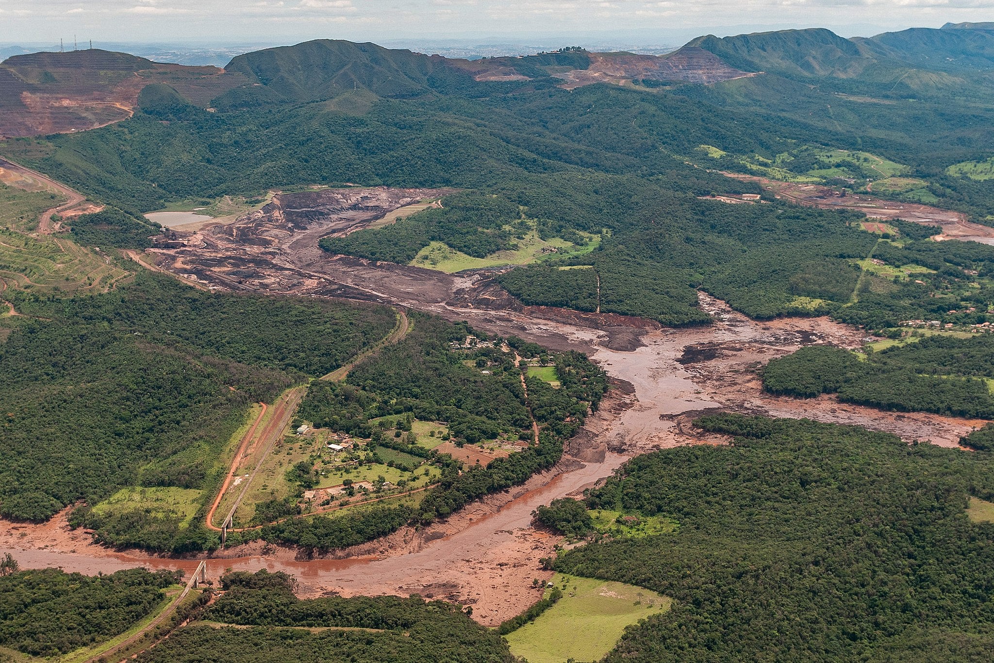
The study used satellite imagery to analyse the Brumadinho dam in the lead up to its collapse. One of Brazil’s worst environmental disasters, the January 2019 collapse of a tailings dam at Vale’s Córrego do Feijão iron ore mine in Brazil killed 270 people. The incident, which followed another Vale-owned dam collapse in 2015, brought new attention to the safety and monitoring processes of tailings dams.
Go deeper with GlobalData

Matthew Hall: What are the current methods used to monitor the stability of dams, and how effective are they?
Stephen Grebby: Current standard monitoring techniques typically include an array of ground-based sensors and monitoring techniques, such as traditional surveying, ground-based radar, and inclinometers for measuring movement of the dam, and piezometers for measuring the water level and water pressure within the tailings.
Although these techniques provide crucial information on the stability of dams, they only really provide measurements at several specific locations on the dam and tailings, which may make it difficult to spot signs of distress.
MH: Can you explain the method you used to show the Brumadinho dam collapse was foreseeable?
SG: We applied a two-stage approach to investigating the Brumadinho dam failure: first, we extracted data on the movements within the dam and tailings structure, then we analysed this data to determine whether there was any anomalous precursory motion that is indicative of a potential failure.
In the first stage, we applied a technique called interferometric synthetic aperture radar (InSAR) to satellite data acquired by the Sentinel-1 mission, in order to map how the entire dam and tailings structure was moving during the 17 months preceding the collapse.
How well do you really know your competitors?
Access the most comprehensive Company Profiles on the market, powered by GlobalData. Save hours of research. Gain competitive edge.

Thank you!
Your download email will arrive shortly
Not ready to buy yet? Download a free sample
We are confident about the unique quality of our Company Profiles. However, we want you to make the most beneficial decision for your business, so we offer a free sample that you can download by submitting the below form
By GlobalDataBy studying the observed movement, we found that different parts of the Brumadinho dam were moving at different rates, some of which accelerated during the two months prior to collapse. Analysing the velocities at which these areas were moving and how they changed over time then enabled us to predict the possible time of failure.
In this case, we found that if the dam was being systematically monitored using our technique, the failure date could have been predicted to within a week of it happening. Crucially, this prediction would have been possible around 40 days prior to the collapse, allowing time for a warning to be raised that the dam was becoming unstable.
MH: Why has this method not previously seen widespread use in the mining industry?
SG: The general use of InSAR for monitoring ground motion is not new, although the application to monitoring dams is relatively new, having only really emerged about five or so years ago. There are some mining companies that do indeed make use of this technology in their monitoring, however, there are a couple of issues that are likely responsible for limiting its wider uptake.
Firstly, the satellite data has to be processed using sophisticated computer algorithms in order to obtain ground motion data. Mining companies wouldn’t typically have the in-house capabilities to do this, so they would need to obtain the processed ground motion data from specialists InSAR data providers. Once they have the ground motion data, the next challenge is then knowing how to interpret the observed motion in terms of the risk of failure.
MH: What were the tell-tale signs in the weeks before the Brumadinho collapse that the dam was at risk?
SG: It is not uncommon for tailings dams to move as they compact and consolidate after new material is added, or when the material swells and shrinks as it dries out following contact with moisture. This motion tends to decrease with time as the tailings stabilise, and it shouldn’t accelerate as that’s a sign that the dam is becoming unstable.
However, our InSAR-derived ground motion data revealed that some parts of the dam and tailings began accelerating during the two months preceding the collapse, coinciding with a period of increased rainfall. We identified this accelerated motion as a precursor to the dam collapse.
MH: Is this method applicable to monitoring all tailings dams, or are there restrictions on where it might be effective?
SG: In theory, it is possible to implement this globally because satellites such as Sentinel-1 are acquiring the necessary radar data at least every 12 days all over the world. However, there a few specific circumstances where its use could be limited.
Firstly, in some cases, the terrain may obscure what can be seen by the satellite – for example, a steep-sided slope may cast a shadow that obscures part of a mine – but this can often be mitigated against if there is data from another satellite track with a different viewing perspective.
Secondly, the presence of water on the surface of the tailings beach can limit the number and spatial distribution of measurements that can be obtained across the dam structure. Finally, dams that undergo very sudden collapses following rapid rates of movement can be somewhat challenging to monitor, depending on how often the data is acquired by the satellite.
MH: What are your hopes with this new study – is this a method that could see adoption soon in the industry to prevent future dam collapses?
SG: It’s clear that this InSAR approach provides complementary information to that which can be obtained using the standard ground-based sensors and monitoring techniques. We therefore hope that the mining sector views this technique as a valuable addition to the monitoring toolbox to help avert similar disasters in the future.
I think the key to increasing the uptake is to try to provide the necessary information in a form that is user-friendly, perhaps as some form of automated early warning service that can predicts the risk of imminent collapse. This is something that our team is now turning our attention to.