
Digital solutions such as AI and remote imaging are becoming crucial tools in the mining industry, offering safer and more efficient ways to identify potential exploration sites and monitoring operations as miners look to cut both emissions and costs. Yet integrating these different technologies to create a single map of a potential site has remained a difficult task, requiring operators to sync separate datasets and proving a time consuming process.
This is where Israeli tech company Exodigo enters the market, acting as a kind of one-stop shop for mapping underground deposits with technology that combines 3D imaging, sensors, and AI to create a single, holistic digital picture of a site. The company launched its first product in February this year, used for underground utility mapping in the construction industry, and development plans are underway for its next product – this one for the mining sector.
Go deeper with GlobalData

Discover B2B Marketing That Performs
Combine business intelligence and editorial excellence to reach engaged professionals across 36 leading media platforms.
We spoke to Exodigo co-founder and CEO Jeremy Suard about his company’s origins, and where it sees itself in the mining exploration industry.
A new means of mapping
Exodigo announced the commercialisation of its subterranean mapping platform in February, coming off the back of its receipt of $29m in seed funding. The group describes its tech as a “safer, non-intrusive, and sustainable way to effectively see underground”, and Suard says their products stand apart from previous geo-mapping services as they combine different sensing technologies to create a single map.
“A challenge that exists in current exploration is that once you find the terrain with interesting underground deposits, it’s really difficult to map the shape and size of them. Right now the main technology to answer this is to do a lot of core drilling,” he says.
“Our approach uses sensor fusion. We take all the sensors that measure things in the ground, and build one map out of all the information gathered from them. Nobody has been able to do this until now, so what we would bring to the mining industry is a better imaging solution for companies to understand the size of a deposit before they do significant drilling and significant construction.”
According to Exodigo, every year more than $100bn is spent on unnecessary excavation and drilling in exploration efforts as miners try to determine the size of a deposit while avoiding subsurface infrastructure such as gas, water, and oil pipelines. As an example, the Common Ground Alliance estimates that $30bn in societal costs result from damages to underground infrastructure each year in the US.
“Environmental concerns are becoming a problem because to determine whether a deposit is worth mining, the only way to answer the question is to drill on the terrain, so it’s sort of a chicken and egg problem because you have to drill to determine if it’s worth drilling,” Suard says. “We want to bring an initial imaging solution that gives way more data to decide if it’s worth drilling in the first place.”
A tech-focused team
The team has its roots in the Israeli army, harnessing training in AI and data gathering to build its tech capabilities.
“My team is trained in algorithms and AI from their time in the army,” Suard says. “Specifically, conducting this kind of work requires skill in signal processing, AI, and software, and it’s really hard to find people who know all three.
“The asset we take from the army is the people and what they learned, and we have access to the top talents of all three categories. A lot of Israeli startups actually come from two specific units of the army that have really good tech people.”
Handpicking a team with this training means that the company is able to combine datasets that previously required multiple teams to interpret.
“Usually for each of the different softwares you have different physicists who interpret each of the signals, but we scan all of them in layers to create a single picture,” says Suard. “The analogy we use is like in the medical world you have a CT scan and an MRI scan and an ultrasound, and a doctor for each of those who can interpret them.
“In mining, you would have a geophysicist who specialises in each sensor. What we do is break that circle and do all of the scans in one to create a single picture of the body – or the deposit.”
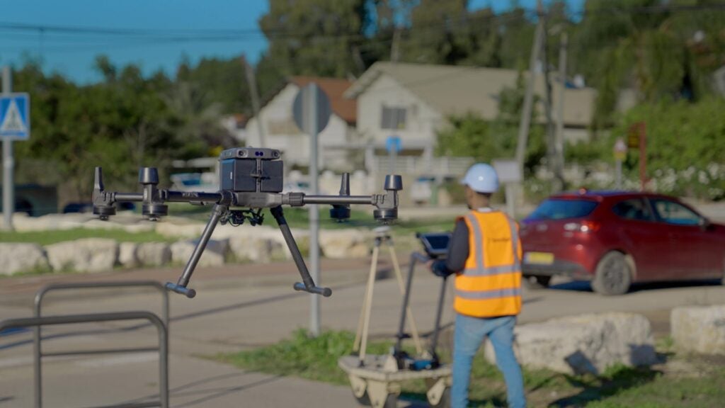
Carried by drones or small carts, Exodigo’s sensor system provides 3D subsurface imaging to detect both ore bodies, and any other objects or infrastructure that could obstruct drilling – including man-made pipes and cables, or natural obstacles such as groundwater.
“We measure signals from a lot of sensors – we can use a drone, a cart, an aeroplane, or even satellites sometimes,” Suard adds. “A lot of these sensors are already there, our company’s speciality is just the software.”
The future of mining
With nations pledging to shift to a cleaner economy, demand for certain mined materials is set to decrease and mining’s future in a green world is slightly uncertain. However, the industry is not in jeopardy yet, and rare earth metals used in green tech solutions, including EV batteries and wind turbine magnets, will see rising demand in the coming years. It is in this sector that Exodigo sees the future of mining, and where its technology can be deployed.
“I think that sector is going to expand a lot. In mining, as well as in oil and gas, there is a need to better understand what you have in the ground before you decide if it’s worth digging – this is going to be really important from an environmental perspective,” Suard says.
“Our tech is also important from a scalability perspective, as we can do a mapping interpretation very fast. Currently, creating a picture from every one of the sensors is a whole process, but with ours it’s almost instant. It’s a few hours at most and this means companies will be able to scan bigger terrains and deeper deposits – expanding mining’s horizons in that sense.”
He adds: “Our solution can also democratise the exploration process. Any junior explorer in the industry could have a state of the art underground imaging solution that hasn’t been available to them up until now because only the big mining companies with good technological teams were able to have access.”
Pilot projects of Exodigo’s construction product are set to begin in California, Florida, and Texas in the coming weeks, and the company’s eyeing up potential design partners to accelerate development of its mining product. According to Suard, the company will use its seed funding to accelerate expansion, with a focus on building a California-based team to support commercial rollout in the US. When asked what’s next however, Suard has his sights set a little further afield.
“In the future, maybe we’ll be able to take our technology to Mars with SpaceX, and map the terrain that’s up there,” he says. “We want to be the best underground imaging solution in the world, and we’ll be keeping up with every new sensor that comes out, and incorporating it into our products. After that, who knows where we could go.”
