Accurate and Cost-Efficient Update of DTM with UAS for BIM
Unmanned Aircraft Systems (UAS) have in recent years become a powerful technique for the generation of Digital Terrain Models (DTM) of relatively limited areas.
You have successfully submitted your enquiry. Someone from our company will respond ASAP
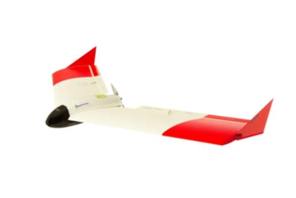
SmartPlanes provide commercial unmanned aircraft systems (UAS), for aerial surveying, remote sensing and surveillance, equipped with high-resolution cameras or other sensors that form an easy-to-use and efficient tool for aerial surveying.
The company’s core products are widely used in prospecting, mine planning, environmental monitoring, and volume measurement of open-pit mines, construction sites, quarries, and dump sites, etc.
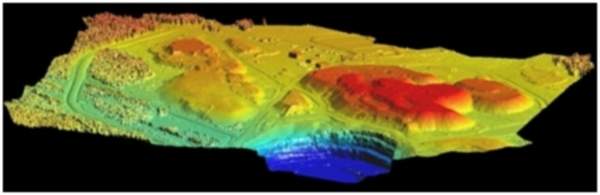
The unmanned aircraft flies automatically over pre-defined areas of interest and takes photos on a regular grid. The resulting high-resolution photos are processed to produce orthophotos and terrain or surface models (DTM/DSM), with very high-accuracy; typically a vertical accuracy of 25mm or better.
Customers will benefit from robustness, cost-efficiency, flexibility, ease-of-use, and up-to-date / real-time information. The solution is utilised by numerous customers and industries worldwide, and proven through thousands of flight missions. SmartPlanes’ solutions focus on enhancing its customers’ productivity by providing reliability, accuracy and performance.
Users can easily be trained to operate the system, and no previous experience is necessary, with either aircraft or aerial surveying.
With our system:
SmartPlanes is pleased to offer an aerial survey system as a turnkey solution for geospatial data providers and end users. The system is a complete package of custom hardware and software.
With the SmartPlanes system, a single person can safely and easily complete surveying and mapping tasks that would otherwise require advanced planning and special expertise using conventional methods.
Our systems save both time and money, allowing resources to be targeted more effectively. The system has proven its functionality after several years in the field and today, our systems are operated on all continents by different users.
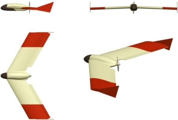
Aircraft:
Performance:
Cameras:
Our custom-designed aircraft is:
SmartPlanes’ systems are designed to operate within existing regulatory frameworks for unmanned aircraft and satisfy permit requirements in most countries.
The system poses minimal risk to bystanders and other aircraft due to its low kinetic energy and mass, plus generous use of shock-absorbing materials in the construction.
We are always looking for new possibilities and application areas. If you have a special requirement that needs a custom solution, please contact us and we can discuss your requirements.
Unmanned Aircraft Systems (UAS) have in recent years become a powerful technique for the generation of Digital Terrain Models (DTM) of relatively limited areas.
What you need to know when you are looking to invest in fixed-wing drone technology for your surveying business.
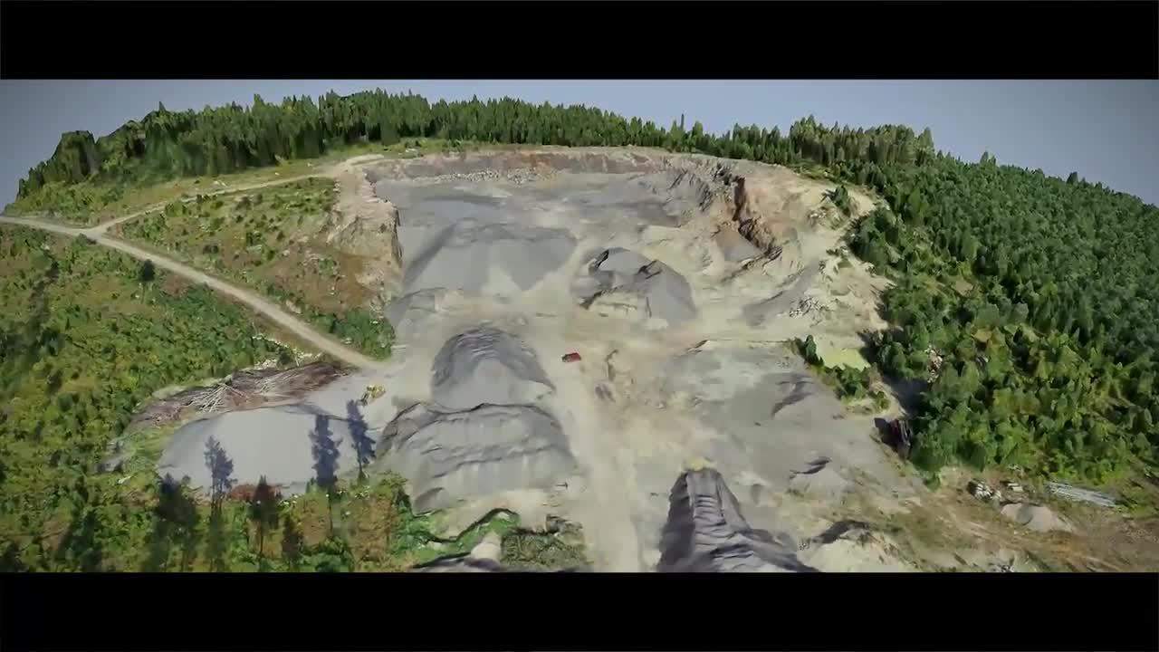
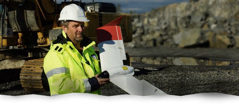
An iron ore mining site in Kiruna, Northern Sweden, was repeatedly surveyed with a SmartPlanes SmartOne-C aircraft, and a rugged tablet computer used as ground control station.

Looking at the drone industry today, there is an obvious trend towards multi-rotors being used for increasingly diverse types of workload. We also see how multi-rotors represent a significant share of the market.
SmartPlanes is to showcase its solutions at Intergeo in Berlin, Germany.
Unmanned aerial systems (UASs) are catching on and gaining momentum in several industries all over the world. Businesses operating in various sectors such as surveying, forestry, mining and agriculture just to mention a few, have started to realize the substantial value of investing in modern drone technology instead of just continuing down the traditional path.
Unmanned aerial vehicles (UAVs) equipped with remote-sensing devices can be programmed to fly predefined search patterns, and collect various types of images, including thermal, optical or captured from an aerial perspective. Ideally, the data captured is transmitted real-time to a ground control station via telemetry link.
Drones play an important role at the Swedish mining company LKAB, which is located in Northern Sweden.
We are really proud and happy that our fixed-wing UAV Freya did so well during tests conducted by Nasa at Reno. Our partner Carbon Autonomous Systems was instrumental in the success of the tests.
With recent technology advancements in small UAS and with reasonable access to affordable sensors, the farmers and researchers of the agriculture industry are starting to adopt UAS technology.
A year ago, SmartPlanes started discussing what unmanned aerial vehicle (UAV) beyond visual line-of-sight (BVLOS) flights really meant, and what impacts it would have on the industry.
SmartPlanes is proud to announce that the SmartPlanes Freya UAV is included in the Nasa UAS Traffic Management (UTM) R&D Technical Capability Level 3 (TCL 3) project, at the FAA-designated UAS test site in Nevada. SmartPlanes is represented by its US distributor Carbon Autonomous.
Smartplanes, a producer of high-end professional drone systems for survey-grade photogrammetric mapping, and Septentrio, a producer of high-performance satellite navigation products will be launching a new post-processing kinematic (PPK) GNSS unit at The Commercial UAV-show in London, UK.
SmartPlanes has after presentations held with Virginia Commonwealth University (VCU), and US Army Corps of Engineers (USACE), received orders for its fixed wing unmanned aerial systems (UAS), Freya, equipped with multiple sensors.
SmartPlanes will be participating at Intergeo, which is being held in Berlin on 7 - 9 October.