CORALIS Mine Planning and Pit Design

CORALIS’ Pit and Dump Design module was made for engineers and professionals who must design and operate open pit mine sites, quarries, landfill sites and other earthworks for industrial use, including infrastructures such as ramps, roads, safety berms and dumps.
This module includes topographic modeling features as well as computer assisted design, 3D display and cartography. Particularly well suited for modeling and operations simulation for massive rock sites, this application interfaces with CORALIS’ Geological Modeling and Block Modelling modules.
1. Topographic modelling
Using topographic survey results at different time intervals during operations, the database supplies a group of reference points (benchmarks) with map coordinates and a layout showing pertinent landforms like benches and roads.
Topographic data can be imported from:
- Most survey devices on the market which supply data in ASCII format
- A scanned map
- 3D DXF format file (Autocad exchange file)
The coordinates (X, Y and Z) are completed by logical data as connecting lines to draw landmarks which will be modeled later, and are saved in a topographic database whose structure allows an easy update of the landscape progression over time based on the different surveys taken.
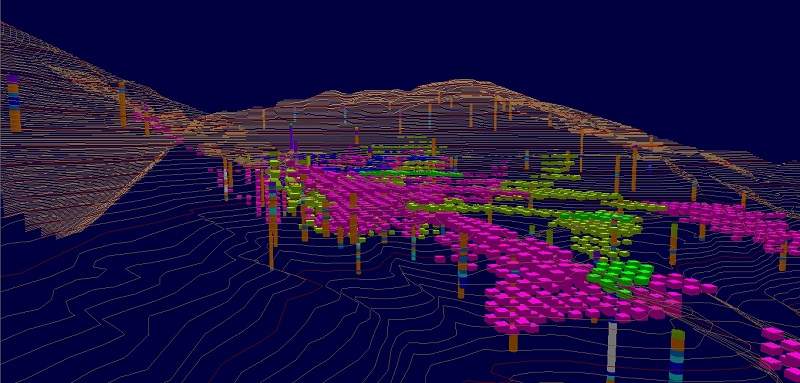
CORALIS software manages topographic databases of multi-million points, which makes it particularly well suited for large area modeling. Surface models can provide tonnage data for excavation and backfilling between two states of a site or two phases of a project.
2. Pit and dump design
Coralis software helps you create excavation and backfilling projects using simulations on a numeric surface model and insures the conception of pits, dumps, industrial earthwork and access roads, from the bottom up or from top down.
Excavations can be created from:
- A limited perimeter at the bottom of a project. This perimeter can be horizontal or positioned on a plane or any type of surface (ex.: Geological body)
- A surface hold limiting the extension of the excavation (ex.: pit edge, town boundaries, etc.) The excavation stops on a plane or any type of surface (ex.: Geological body)
Dumps can be created from:
- A horizontal perimeter on a plane indicating the top of the dump
- A surface hold limiting the extension of the bank (bottom of the slope)
Ramps and roads are created from a series of axis points (x, y, z) and road width.
Banks are determined via:
- Average pit slope
- Benches, customized to specific widths and heights
With its powerful calculation algorithms, CORALIS displays the results within seconds for the requested project phase. The user can then move on to the next phase if the results are adequate or he/she can modify the parameters (perimeter, road axis, slope angle, etc.) before recalculating.
CORALIS Pit and Dump Design module can combine various design phases to build a complex project by:
- Producing variable slope angles on different bench faces
- Elaborating operation phases while taking into account the final pit design
- Simulating an excavation which is limited by one or more geological bodies.