

Airborne electromagnetic (EM) surveying is a method used by mining companies to determine the geological structure of the earth at potential mining sites, obtaining detailed insight into where and how to drill. And while it’s neither a cheap nor easy technique, it’s one that’s quickly grown in popularity over recent years as operators seek to de-risk prospects before engaging venture capital firms.
Go deeper with GlobalData

Discover B2B Marketing That Performs
Combine business intelligence and editorial excellence to reach engaged professionals across 36 leading media platforms.
Its popularity can be put down to several factors, as not only does EM surveying allow companies to gather data from much deeper under the surface than many other surveying techniques, the data provided is extremely high-resolution. Moreover, EM technologies are improving all the time – both in terms of the equipment used to collect the data and the software used to analyse it.
Elly Earls meets the British Geological Survey’s authority on airborne geophysics, David Beamish, to find out how much the technique has advanced, what a typical survey involves and how the latest earth modelling software can be used to translate the data collected during surveys into useful information for mining companies and their prospective investors.
Elly Earls: How do airborne EM surveys work and what equipment is required to carry them out?
David Beamish: Airborne electromagnetic surveying is an active detection method which, through measuring how conductive rocks are, gives mining companies a better idea of the earth’s structure and the arrangement of deposits at depth. This then helps them better define where they have to drill and at what angle to intersect potential targets.
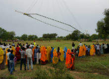
When it comes to the equipment, this particular type of survey requires a source of EM field, which is generated using a large transmitter coil, fixed onto a helicopter or a light fixed-wing aircraft. You also have a receiver on board, which measures the EM response.
During the survey, the aircraft needs to fly as close to the ground as possible because you get more signal back from the earth, although regulatory and safety issues come into play here when it comes to the practicality of what’s permitted and what’s not. Then, it’s a matter of covering an exploration target and the area around it, as you want to get a bit of regional geological context. This is always done by flying in parallel lines because that helps with the processing of the data.
EE: Why are the surveys needed and how do they fit into the context of other techniques?
DB: Airborne EM surveys have a particular role in the context of the other measurements you can make and that role is that it’s a direct detection method, while the other methods – such as magnetic surveys, radiometric surveys and gravity surveys – are passive. EM is the active method, where you generate fields and measure the returns.
Plus, if you get it right, you can go to 500m below ground and it can also be done at high-resolution. It’s higher cost than other methods but it delivers information that is more directly applicable to the mining sector – the other methods don’t really compete with it.
EE: How much has EM technology advanced over the years?
DB: The technology has got better and better incrementally in terms of the sensors, the power of the active source and the software methods, which are used to turn the data collected into a product that’s helpful to mining companies.
Because it’s an active method, you’d like it to go as deep as possible so you don’t miss anything, so that increase in the overall depth you can investigate has been very important. The ‘transmitter moment’, which basically means how much power the system has got, has also increased, and the electronic side has improved as well which in turn has helped the sensitivity of the sensors. Finally, the software and visualisation side of things has also improved enormously.
EE: Tell me a bit more about the software that’s used to translate the data into useful information for mining companies. How does this work?
DB: We use what’s called an ‘earth model’, which translates the data collected into a 3D picture of the conductivity structure below the ground. The model is developed with existing data from regional or countrywide surveys (these would generally be passive surveys such as magnetic or radiometric surveys) and the newly gathered data from the EM survey.
You add these other data sets to increase the understanding of the geology or ‘de-risk’ a prospect so it can be put out into the venture capital side of the market with the aim of stimulating investment. The more information you can give the earth model, the greater the confidence boost for potential investors.
When it comes to the technology itself, the most advanced aspect of the software is what we call ‘inversion’, which converts geophysical measurements into 3D images of the subsurface. The challenge is to convert high-resolution data into a true 3D model, which is beyond the scope of most computers’ power. Today the data is fit for purpose, which is the ultimate aim, but there’s still room for improvement and researchers are working on it.
EE: How much has the use of airborne EM surveying increased and what improvements can we expect over the next five years?
DB: There’s been quite remarkable growth in this area, because you can mobilise to anywhere in the world and it’s very effective in de-risking prospects. However, at the moment, with the downturn, there’s a lot of equipment not being used, so from that point of view, if exploration capital dips, then so does airborne surveying.
In the next five years, there will definitely be improvements in technology. On the actual EM side, this is always incremental as it’s the safest route to improving things, and the biggest improvements will probably be on the software side, so how we produce the earth model from the data. The sensor side of things has probably reached a sensible plateau.
