

In September, the Geological Survey of Queensland (GSQ) wrapped up its project using soundwaves to identify critical minerals across North-West Queensland.
Established in collaboration with Geoscience Australia, the $4.5m Boodjamulla–Croydon Deep Seismic Program used three ‘Vibroseis’ trucks to send low-frequency soundwaves into the ground to map underground rock formations and uncover untapped deposits of critical minerals such as copper and zinc.
The survey comes as the Queensland Government looks to reinvigorate the state’s resources sector and attract fresh investment into mineral exploration, with minister for natural resources and mines, Dale Last, saying the project could give Queensland a “head start” on the next wave of mining wealth.
While results from the project are still being reviewed, Mine Australia spoke with GSQ to find out more about the project, and what it could mean for Queensland’s economy and exploration landscape.
Scarlett Evans (SE): Can you outline the project, its aims and what kind of data it’s expected to generate?
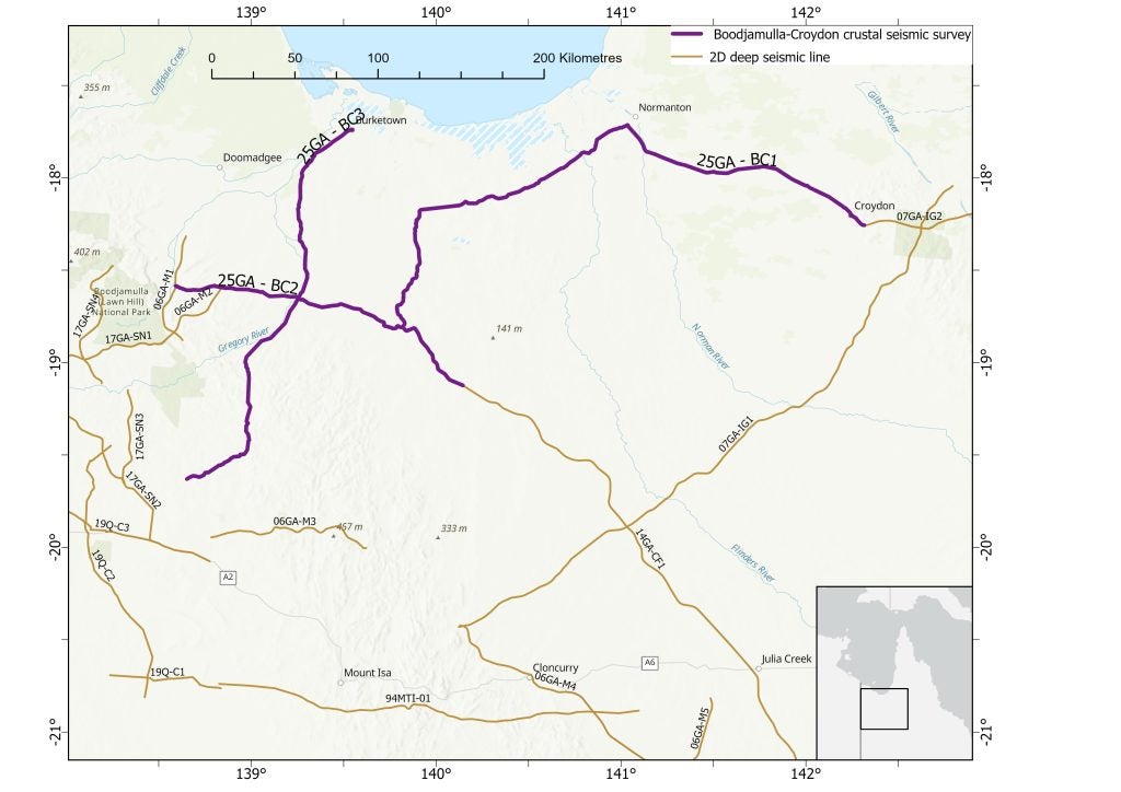
GSQ: The Survey ran along public roads between July and September 2025, consisting of three lines, totalling 842km, spanning from the western subprovince of the Mount Isa Inlier across the Carpentaria Basin and into the Croydon Province of the Georgetown Inlier.
The aim was to improve understanding of the region’s crustal architecture and large-scale tectonic setting, including features such as basins, deep faults, and crustal boundaries that are critical to the formation and localisation of mineral and energy resources. The lines were surveyed in two stages to highlight both near surface (0-2km) and deep crustal (from 2 to ~60km depth) resulting in a series of deliverables tailored for both resources explorers and researchers with one survey.
The raw data will be released by December 2025, with the processed data expected to be released in early Q4 2026.
SE: Why is North West Queensland a focus area for this kind of exploration? What makes this region geologically or economically promising?
GSQ: Mining has played a defining role in shaping the economy and communities of North West Queensland for more than a century.
Over the decades, the region has expanded from small-scale prospecting to large-scale, world-class mines producing copper, lead, zinc and silver. Mineral exploration has until only recently focused on outcropping geology (where the prospective geology is found at the surface), but geophysical methods show us the geological trends of this rich province continue to extend outward of this outcrop area obscured by more recent cover geology.
Precompetitive data, like the Boodjamulla-Croydon Deep Seismic Survey, allow explorers to expand their exploration programs into these areas.
SE: Can you explain how the Vibroseis truck technology works?
GSQ: Vibroseis trucks are equipped with a heavy metal plate that is lowered to the ground at a defined interval to send vibrations – the seismic sound waves – into the earth. The soundwaves travel through the subsurface and bounce or reflect off different rock layers and features in the earth.
A network of geophones (similar to microphones) is laid out along the survey line, and these record the returning reflected sound waves. In the field, survey lines are usually set out along existing tracks or roads. The trucks continue down the line repeating the process at a set interval, in this survey every 40m.
SE: Why is Vibroseis truck technology effective for mineral exploration?
The vibroseis process is clean, precise and easy to repeat, causing very little disturbance and can be adjusted to suit environmental or community requirements. Once the survey is complete, the recorded data is processed to create a detailed cross-section of the subsurface. Because the vibration signal is known, the data can be filtered and combined to create clear, high-quality images even in noisy or complex ground conditions.
While a seismic survey can’t distinguish minerals directly, it is especially useful for mineral exploration because it gives a detailed picture of the subsurface.
SE: Dale Last mentioned Copper and zinc as key targets – what is the strategic importance of these minerals, both for Queensland and nationally?
GSQ: Copper and zinc are both strategic materials in that they are important for the global transition to net zero and broader strategic applications, specifically the priority technologies set out in the Critical Minerals Strategy and are in demand from our strategic international partners.
Both copper and zinc feed into Australia’s energy transition, including having uses in vehicle electrification, wind turbine and solar panel manufacturing.
The global transition to a net zero economy and sustainable future will require commodities like copper and zinc, and it will continue to see regions like North West Queensland feeding into the global supply markets.
SE: How will the data from this survey help direct future projects/investment?
GSQ: The raw data for this survey, the processed data, geological interpretation and reports will all be used internally to direct future projects at the GSQ focused on North West Queensland mineral systems.
The Boodjamulla-Croydon seismic survey will form a foundational dataset in the recently announced Georgetown-Julia Creek Deep-dive project of the Resourcing Australia’s Prosperity initiative. This project will deliver an improved geological framework (surface to lithosphere) for the region which, when combined with resource potential assessments, will provide a holistic view of the region’s multi-commodity resource potential and opportunities for development.
SE: From an economic development perspective, how might this survey contribute to new mining opportunities in Queensland?
GSQ: The resources sector is a cornerstone of Queensland’s economy, contributing significantly to employment, regional development and the state’s overall prosperity.
The Queensland Government’s targeted initiatives like the collaborative Boodjamulla-Croydon Deep Seismic Survey play a pivotal role in supporting this vital industry by fostering innovation, enhancing sustainability and ensuring global competitiveness.
The survey is just a part of the precompetitive data ecosystem created by GSQ and Geoscience Australia alongside airborne and ground geophysics, geochemistry and geological mapping.
The data and interpretations will be freely available, giving experts access to quality geological insights they could not generate on their own. It reduces unknown elements and therefore assists to de-risk exploration in uncovered areas.
A strong pipeline of exploration will set the stage for the future of Queensland’s resources sector, which returns billions of dollars to Queenslanders every year.
