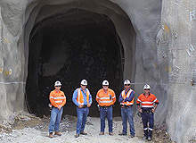
The Isambara licence falls within the Simba project, originally a 70-15-15 joint venture between MDN Northern Mining (as operator), Lakota Resources and Jope Business Associates, covering a territory of 40km² located 28km north of the Tulawaka Gold Mine.
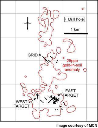
Initially identified by soil geochemistry surveys over a length of 5km, the Isambara target has subsequently undergone detailed soil geochemical and gradient induced polarisation (IP) surveys and a series of drilling phases throughout 2007.
Recommended White Papers
Recommended Buyers Guides
MSN ownership
As part of the signed agreement between the groups, MDN exercised its rights to dilute the interest of Lakota and Jope in October 2008 and took 100% ownership. The failure of Lakota and Jope to contribute their pro-rata interest in the project resulted in the dilution of their interest to 1% net smelter return with no right or interest as parties to agreement.
Geology
The geology is principally gold-bearing quartz with other gold intersections of mainly granite with pyrite. Mineralisation of the eastern target area is in shear zones through granodiorite intrusions, while the western target is a volcanic host at contact with the batholith. The best sections lie within pyrite-rich quartz veins, with most being hosted by sheared granite containing associated minor sulphides.
These shear zones themselves appear to be delineated by a succession of high-grade gold lenses and low-content areas, characterised by multiple injections of quartz, strong alterations and sulphide deposits, dominated by pyrite.
Observations
The gold bearing zones are frequently intersected, creating pronounced displacements to the left (sinistral). This indicates high-grade gold mineralisation is located below 40m.
Displacements at dykes indicate that several areas are in a continuous zone of mineralisation. The geometry of the deposits favours that gold bearing zones remain open laterally. The accumulated drilling data on Isambara is discovered as ‘lead structure’ hosting higher grade gold values with numerous adjacent intercepts of lower grade structures mineralisation forming a 10m to 25m envelope.
Drilling results
In September 2006, 39 reversed circulation (RC) holes were drilled for a total of 1,713m, to investigate initial drill intersections from the previous year and one hole in particular – ISRAB-21. This intersected 8m at 14.54g/t Au, with a check analysis of 13.49g/t Au from 45 to 53m within a pyrite-rich quartz vein lying in a shear corridor; and 5m at 14.93g/t Au, with a check analysis of 13.22g/t Au from 1 to 6m in the ferricrete. Four phases of drilling were subsequently planned for 2007.
Concentrating on a number of features identified by the earlier surveys as favourable to gold mineralisation, the first of these confirmed the extension of the gold structure over a length of 1.3km, laterally open over a possible distance of 5km. Completed in May, this involved 25 RC holes being drilled for a total of 1,487m, though the drilling techniques used did not allow the true width and orientation of the mineralised intersections to be accurately determined.
Holes were drilled at a spacing of 50m to either side of ISRAB-21, as well as a twin and a scissor hole, but all failed to intersect the mineralised quartz structure that the earlier drilling had revealed.
As a result, it was postulated that the vein might be held within a tension fracture, itself running at a high angle to the direction of the main shear, probably lying sub-parallel to the initial drill fence. To test this, two additional scissor holes (ISRC-49 and 50) were then drilled at near-right angles to the original fences, which successfully intersected the gold-bearing quartz seam.
The second phase, which concluded in September 2007, comprised nearly 4,000m of reversed circulation drilling and over 2,000m of diamond drilling. This enabled the gold mineralisation context of the east target to be specified. In addition, it also led to the discovery of a new mineralised zone 2km north of previously known targets.
The results of the diamond drilling also highlighted similarities with the gold deposits of the Bourlamaque batholith found at the mining camp of Val d’Or (Abitibi) and with the Ferderber gold deposit at the Belmoral Gold Mine. This produced over 355,000oz of gold with an average grade of 6.46g/t; the Isambara find shares many details of geology and mineralisation with the old Belmoral workings.
The second phase yielded broadly similar findings to preceding investigations and in the eastern target area, where the exploration efforts were chiefly concentrated. Results indicated 17.40g/t of gold over 1m or 9.13g/t of gold over 1m and 2.40g/t of gold over 4m.
Eight diamond and seven RC drill holes produced a total of 26 gold intersections with gold grades higher than 1g/t, ranging from 0.5–4m in thickness.
In addition, a total of 600m of RC drilling was carried out on the newly indicated deposit, one hole returning 1.66g/t gold over 1m to a depth of 2m, while another yielded seven gold intersections with grades greater than 1g/t of gold. In particular, it returned results of 5.54g/t gold over 2m at a depth of 64m and 2.84g/t of gold over 5m at a depth of 119m.
All samples underwent fire assay analysis at the SGS laboratories in Tanzania and were certified in accordance with the necessary international standards, 12% control samples being included in MDN’s rigorous programme of analytical grade verification.
Phase III results
A third phase of drilling began in early October 2007, which was intended to explore mineralisation within the previously unexplored zones of the structure, while also establishing the extent of the richest and most consistent sectors with greater precision.
The company announced the results of its 2007 drilling programme in January 2008. More high-grade gold was intersected over a distance of 2km along the Isambara shear. An aggregate of 2,981m in 31 RC holes (ISRC-149 to ISRC-179) were drilled under third phase.
Phases 1 and 2 successfully confirmed the presence of gold mineralisation within distant zones of the identified ground anomaly and at more important depths than those that earlier RC drill holes had tested. The original RC drill hole – ISRC-21 – intersected 3m at 8.63g/t Au, with a check analysis of 6.95g/t Au from 40 to 43m.
New drilling programme
One of the key objectives of the drilling programme scheduled for 2009 is to establish the continuity in high grades within the same structure, while determining the physical continuity in high extremity. Furthermore, the exploration programme will be able to complete a detailed geochemical soil survey for collecting new samples in respect to sinistral displacements and to complete a compilation of anomalies in the identified structures.
The programmes identified high grade gold mineralisation more than 10g/t at 40m below surface. Holes below this depth did not test mineralised zones. The gold bearing structures remain open at depth and laterally. The high grade zones extend for several hundreds of metres until it is intersected by mafic dykes. The gold-bearing zones at Isambara are oriented at 310 degrees and plunge north-east.
The soil sampling programme of the project was completed in April 2009. Results announced on 28 May 2009 confirmed the geometry of gold-bearing zones, the occurrence of left-hand sinistral displacements and the existence of multiple parallel gold-bearing zones. The southern zone of the Isambara project area has been identified as a series of parallel gold-bearing zones along a 1.3km strike length. The area is characterised by major lateral extensions.
Drilling began in mid 2009 at the Southern Area. Results confirmed the north-west geometry of the vein-hosted mineralised zone. The mineralised zone appears to be continuous more than 25m to 500m and having 10 to 100m width. The density of the small sheeted veins control the grade.
In the central and northern zones of the Isambara project zone, the soil anomalies extend from the southern zone. Drilling of the central and northern zones’ soil anomalies will be undertaken in Phase II which is scheduled to commence by mid 2010.