
“By sea, land and air, we prosper.” While the City of Vancouver arguably holds the copyright on that particular motto, it seems that in the rush to replace dwindling resources, the global mining industry has also embraced the same thinking – especially when it comes to novel methods of surveying and exploration.
Data from space
Go deeper with GlobalData

Discover B2B Marketing That Performs
Combine business intelligence and editorial excellence to reach engaged professionals across 36 leading media platforms.
By its very nature, mining is intrinsically dependent on both geological and positional data, making it arguably the most spatially aware of all industries and an obvious target for geospatial technologies. While the growth of geographical information systems (GIS) over recent years has been reflected widely across the industry, its greatest advantage has been enhancement of asset discovery.
The ability of GIS to collect, collate, compile, archive and access multiple datasets in combination with wider geomatic mapping and state-of-the-art software, can yield sophisticated, aggregated, multi-layered renderings quickly and with remarkable accuracy. As a consequence, with market forces increasingly singling out ever more remote and inaccessible tracts for exploration, the use of GIS together with satellite imaging is becoming crucial for the prediction of mineral potential.
The partnership is, of course, a natural one and the logic compelling; with sensor payloads sensitive to multiple bands of light, satellites offer the opportunity to examine hidden topographical features via wavelengths invisible to the human eye.
Couple this with the latest generation of 3D terrain visualisation programs, high-end orthorectification software, and multispectral and thermal infrared imaging trained experts are now able to reveal geo-structural details with unprecedented clarity.
Add aerial LiDAR, laser and hyperspectral technologies to the mix, and it becomes easy to see why the list of users – including the likes of Anglo American, BHP Billiton, De Beers, Exxaro and Vale – sounds quite so like a who’s who of the industry.
Robots and unmanned vehicles
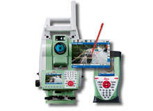
The slightly sci-fi feel to the new tech goes further with the rise of robotic systems and unmanned drones. Leica Geosystems’ latest offering in robotic imaging total stations, the Leica Viva TS15, which was launched in October at InterGeo 2010 in Cologne, is a case in point.
Its advanced imaging functionality, image-assisted surveying and documentation capability combines seamlessly with dynamic tracking and the onboard user-friendly SmartWorx Viva software to provide a quick and precise surveying system that is both easy and intuitive to use. The data gleaned allows mine surveyors to work directly on the 3D design, while simultaneously superimposing measurement data onto the layout itself.
The robots have taken to the air too, as unmanned aerial vehicles (UAVs) stretch their wings beyond their almost exclusively military ancestry.
Capable of sustained, long-distance flight, at low altitude and low airspeed, the same technology that suits UAVs to reconnaissance missions in Helmand or Basra serves equally as well for surveying stockpiles or exploring remote tracts of land for mineral deposits.
Nevertheless, although the industry’s collective interest has undoubtedly been piqued, to date issues of safety, conformity and standardisation within the civilian UAV sector has mandated a slow actual take-up of the technology. In the long run, given the extraordinary cost-effectiveness of the solution when compared with photography and data acquisition via conventional piloted fixed or rotary wing routes, it seems inconceivable that UAVs will not eventually find their place in the inventories of mining companies and surveyors world-wide.
However, it is not just from the air that unmanned vehicles may help to change the face of mineral surveying and exploration. At the end of April, India’s recently developed remotely operated underwater vehicle successfully recovered samples of manganese nodules from a depth of over 5,200m and they are not alone. The sea might be about to start giving up some of its oft-discussed vast mineral potential.
Deep ocean deposits
Indeed, the oceans could become the battlefield for exploration companies over the coming decade – at least that’s the view of Keith Kohl, Editor in Chief of Energy and Capital, who foresees mining interests scouring the seabed for metals in the same way as their oil and gas counterparts started searching offshore over half a century ago.
Looking at the approach being taken to the Solwara 1 project by Nautilus Minerals – one of only a handful of companies currently active in the space – his analogy seems a particularly apposite one. The company is, according to its own website “following the lead by the offshore oil and gas industry to tap vast offshore resources.”
Nautilus is the first company to explore the ocean floor on a commercial basis for massive sulphide systems – the rich submarine residue left at the site of oceanic ‘black smokers’, that hold the promise of high grade copper, zinc, gold and silver – using technology derived from the offshore energy sector. Solwara 1, currently under development off the shore of Papua New Guinea, is the world’s first seabed copper-gold project and when operational, will mark the dawn of a new industry in deep water seafloor resource production.
As offshore consultant, Richard Lightman, explains, with the oil and gas industry having honed undersea survey methods through decades of experience and growing necessity, there is a massive potential dividend to come for this nascent submarine mining sector.
He points to the first commercial multi-vessel, full-azimuth seismic acquisition programme, which was begun in October by WesternGeco in the waters of the Gulf of Mexico.
“You’ve got four vessels travelling on a circular path, using multi- and wide-azimuth methods to acquire ultra-long offset marine seismic data. Granted, interpreting that will call for some effective 3D software and reverse time migration, but the bottom line is that in a difficult location, you’re going to get enhanced image uplift and a higher sing-to-noise ratio – and that means greater survey accuracy. It is a short hop to see that used for seabed mining too.”
With Russian flags being planted deep beneath the Arctic ocean and Indonesian surveys of the underwater meeting point of the complex Indo-Australian / Pacific / Eurasian ground-plate revealing sulphide, pyrite, barite and marcasite, from pole to equator, Kohl’s words may yet ring true.
One thing seems clear; when it comes to surveying and exploration, the technology stands ready to move mining into some of the most challenging environments on earth.
