
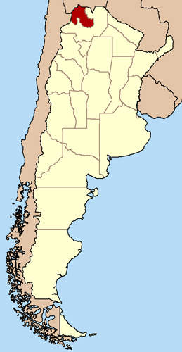
El Torno is a gold deposit located north-west of Argentina in Andean Cordillera of the Jujuy province near the Bolivian border. The deposit lies over an area of 78km² that sits 4,000m above sea level. It contains three types of gold deposits: A large gold-bearing quartz vein system that trends north-south and measures 14km in length and 20m in width, dispersed gold in small veins separated from the main system, and eluvial gold deposits composed of weathered bed-rock. The mine is being operated by Soltera.
Soltera signed an agreement to develop eluvial gold production at the property with Goldlake Group on 25 June 2010. The agreement will expire in July 2011. Under the terms of the agreement, Goldlake will be providing $1.5m for property maintenance ($200,000), carrying out the initial test work on the significant gold targets of the project ($300,000) and resuming production of alluvial gold ($600,000). The agreement allows Goldlake to develop a natural/ethical gold production project in line with a supply agreement with Cartier.
Recommended Buyers Guides
Eluvial gold sampling, which was carried out in September 2010, concluded that the gold tonnage available in the area was insufficient for production purposes. Based on these results, Soltera will continue to explore gold bearing areas discovered in the 2008 geochemical surveys.
El Torno has been a gold producing mine for several years. The deposit has approximately 1,000m of underground galleries created by Incas and Spaniards. Since 1997, exploration was carried out at an estimated expenditure of around $1.35m by Puma Minerals and then Industrias Peñoles.
Geology
The deposit is located over an area dominated by metamorphosed sandstones and shale. Formed during the Ordovician geologic period, the shale is folded along the north-south axial planes. It contains open and isoclinal folds apart from axes that are disjointed by cross faults at certain places.
The sedimentary sequence in the region contains lower and upper levels. The lower layer is more permeable and rigid and comprises rough sandstone. In contrast, the upper layer is more flexible and is made up of fine grained inter-layered sandstone and shale. The sandstone and shale are intersected by a set of large gold bearing quartz veins that are concentrated along the axis of the north-south fold.
The veins are sub-vertical and inter-layered with sedimentary rocks and are dislocated by cross faults at certain places.
Reserves
The vein can produce over 500,000oz of gold over a length of 1.3km and a depth of 100m. At a further depth of 400m, the vein can produce two million ounces of gold at an assumed grade of 10g/t gold.
Mineralisation
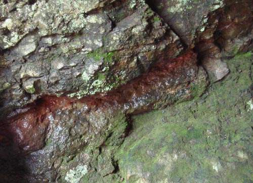
Gold is deposited in the western side of the vein along a 2m-wide zone. While appearing free, the gold is often associated with limonitised pyrite. At some places, the main vein contains broad stockworks of small quartz and pyrite veins. These stockworks stretch outwards from the main vein up to 300m.
Exploration
As of September 2009, Soltera has conducted two stream sediment geochemical surveys and a detailed structural survey of the area. The studies revealed the open-pit and underground potential of the mine. Commissioned in 2007, the first stream sediment geochemical survey covered an area of about 100km². It was intended to explore the other gold-rich parts of the vein apart from the central and western sections.
The results revealed gold mineralisation along the entire 14km length of the vein. A series of unique and strong anomalies were found along the vein’s total length. Strong and wide gold anomalies up to 2km in length and 1.5km in width were also found for 2km from the main vein system.
The main vein system was studied through structural mappings completed in April 2008. It covered parts of the vein that were exposed in previous mine workings and at the surface. The study revealed thickening of the quartz veins at the anticlinal axis. It was also found that the quartz veins run parallel to the sedimentary layering at a broad distance.
A second stream sediment geochemical survey was conducted in mid-2008. Covering an area of 15km² with 1,000 samples, the survey focused on the anomalies discovered in the first survey. It confirmed the presence of a significant gold anomalous zone about 5km north-south.
The 2km-wide gold anomalous zone extended beyond the main vein to the country rocks. A 1km-wide separate anomalous zone was also located at about 1km east of the main vein.
Soltera will continue to conduct exploration programme on the geochemical anomalies and the main vein system in future. Geophysical surveys, surface samplings, trenching and shallow drilling will be performed to test the anomalies. Apart from conducting geophysical surveys, the vein system will be tested by mapping previous gold workings and conducting a limited programme of diamond drilling.
The eluvial test carried out in September 2010 covered an area of 40ha. Around 392 sample tests were conducted and about 95% of them revealed that there were traces of gold but with a value less than 0.1g/t. Only six samples showed the value to be more than 1g/t.
Costs
In July 2007, Soltera entered into an option agreement with Incas Mineral, and Manuel Bernal Mateo, a private individual, for exploration. Incas was acquired by Soltera in July 2007. Under the terms of the purchase agreement, Soltera has to pay $2,970,000 by December 2012. As of June 2010, Soltera paid $350,000 of the net amount.