
From the first day when man began digging up the earth, gathering resources and making a huge mess in the process, the conflict between effective mining operations and its environmental impact has divided societies. Beginning with the Industrial Revolution, the economic imperatives facing our society have powered the need to exploit mineral deposits.
The hunger for resources that so characterised this ‘new age’ also tended override the environmental impact of mining operations. However, in the 1960s community and consumer demands for sound environmental practices began to become an issue for the mining industry.
Go deeper with GlobalData

Discover B2B Marketing That Performs
Combine business intelligence and editorial excellence to reach engaged professionals across 36 leading media platforms.
Gathering resources while leaving the smallest environmental footprint has become very much a mantra for modern mining enterprises.
This change in thinking has forced the adoption of a number of new technologies that if fully exploited would result not only in good environmental practices, but also have the potential to substantially reduce costs and improve productivity.
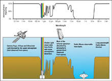
Air and spaceborne sensors
Central amongst these emerging technologies has been the introduction of hyperspectral imaging. Developed for military applications at the height of the Cold War, hyperspectral imaging is designed to take advantage of a well-known physics phenomenon in which the spectrum of reflected light precisely corresponds to the physical make-up of the surface reflecting it.
Differing from multispectral imaging, hyperspectral sensors are designed to undertake high-resolution snapshots in tight spectral band of less than 20nm within the visible and infrared spectrum (0.4–2.5 micrometer). By using wide light spectrum scanners aboard satellites or aircraft, it is now possible to image the Earth’s surface in swaths of approximately 150km² each hour.
Like any new technology, hyperspectral imaging is not without its share of teething problems. The sheer wealth of data produced by hyperspectral imaging has proved its greatest drawback.
However, with the recent advancement in computer processing capabilities and data storage the field application of the technology has begun in earnest.
Among the many programmes emerging has been the CSIRO’s (Commonwealth Scientific and Industrial Research Organisation) Minerals Down Under Flagship Next Generation Mineral Mapping project, which is centred around utilising the data collected to produce accurate mineralogy maps. Initially comprising some 150,000km² of outback in Queensland, the final vision is for the creation of a complete mineral map of Australia.
Compared against traditional airborne prospecting techniques, hyperspectral imaging offers the ability to conduct rapid, large-scale and low-cost surveys with the minimum of infrastructure. In addition, the cost, logistic and informational benefits that it offers prospectors; hyperspectral imaging introduces a mechanism to conduct entirely non-destructive, environmentally friendly survey operations. In this way the technology makes prospecting an extremely environmentally friendly process.
Ground-based geophysical systems
Complementing the introduction of air and spaceborne imaging technologies has been the introduction of a range of deep-scanning ground-based electromagnetic sensors. These technologies sense the passive electromagnetic (EM) field around the Earth. This field is considered to be created by dielectric differences in subsurface formations.
While the technology is still suffering teething problems, the analysis of this EM field provides the ability to identify electrically conductive ore deposits. Originally developed in Russia in the 1960s passive EM mapping succeeded in discovering one of the world’s largest gas fields in Western Siberia, the Urengoy field.
Despite early success the wide-scale application of passive EM mapping did not flourish, as a result of the inherent problems with the technology. The key problem was the technology’s depth limitation of 200m and non-unique results that introduce a high level of uncertainty to results.
In early-2000 an Australian company called WMC Resources collaborated with Electromagnetic Imaging Technology (EMIT) to develop a new generation of passive EM imaging system. The Geoferret system is based around a series of distributed EM sensor coils and associated receiver electronics that provide simultaneous data acquisition.
Combined with a global positioning system integrally attached to each sensor, the system delivers synchronised time and positioning measurements. It does this by utilising high-sensitivity and low-noise sensors coupled with the high-speed, real-time, multiple simultaneous measurements. Geoferret has demonstrated in field trials to identify electrically conductive ore deposits at depths of greater than 500m, often under the presence of conductive cover materials.
In addition to allowing for the enhanced greenfield and brownfield exploration, passive EM imaging has the potential to minimise the drilling of dry holes or the need for invasive exploration techniques. Again this is a new technology that will improve the productivity of mining while minimising the impact on the environment.
Hand probes and sensors
At the most basic level the introduction of handheld probes and analytical tools is providing the field geologist with the ability to conduct highly accurate onsite evaluations of core samples.
Shortcutting a process that once required laboratories and significant experimental equipment, the introduction of handheld probes like the MPP-EM2S+ has made a huge difference when it comes to productivity and environmental footprint. These tools offer the ability to undertake the onsite assessment of the magnetic and conductive properties of core samples, delivering real-time data for immediate evaluation.
This availability of instant feedback on core samples makes it possible to assess the commercial viability of mineral deposits and further drilling operations on a real-time basis, allowing for the enhanced targeting of resources and the minimisation of the impact that exploration activities has on the surrounding environment.
Software tools: geological modelling and mine management
From the early days of hand-drawn maps, the information technology revolution has resulted in a paradigm shift in the analysis of the data collected in survey and exploration operations.
Developed since the late 1990s, the variety of commercial software programmes, suites and GIS tools now available is incredible, with literally thousands of applications. Though varied in style and format, the core aim of the software is to allow for the collection of geophysical data followed by the organisation, analysis and presentation of the data in convenient and easy-to-use formats.
Among the available software, packages like Oasis Montaj, Target for ArcGIS, Profile Analyst and LAGGER offer the ability to combine the geophysical and geochemical data collected from images, maps, drill holes and electromagnetic surveys to create 3D models of the geological environment surveyed. These systems allow for highly effective evaluation of survey data to generate an accurate picture of the mineral deposits often without the need for extensive, expensive and environmentally damaging exploration works.
The implementation of such prospecting software has been paralleled by the development of mine modelling and management software.
Current mine management software packages such as Vulcan, Datamine and Surpac, when combined with the geotechnical data collected by modern exploration techniques, allow for the creation of comprehensive mine models. These programmes look to maximise revenue by being super efficient in the management of a resource being mined and a welcome by-product of such a focus is often a less environmentally damaging approach.
It is the use of these models that offers the greatest reward to mine operators and the environment by allowing for the detailed modelling of a wide variety of mining operations, schedules and designs to evaluate their effectiveness.
While legislative and community pressures continue to force exploration and mining operations to operate in an increasingly environmentally friendly way, arguably the most effective long-term driver of good environmental practices will be the economic benefits that can be drawn from them.
The emerging exploration and planning technologies offer significant cost reductions and increased accuracy of results, whilst also operating in non-invasive nature, effectively killing two birds with one stone.
