Department 13 International Pty Ltd (D13) is a 100% Australian owned and operated Counter Unmanned Aerial Systems (C-UAS) technology and service provider.
Make an enquiry
Subscribed
You have successfully submitted your enquiry. Someone from our company will respond ASAP
Department 13 International Pty Ltd (D13) is a 100% Australian owned and operated Counter Unmanned Aerial Systems (C-UAS) technology and service provider.
Located in Canberra, Australia D13 is an original equipment manufacturer (OEM) of highly specialised hardware and software that is capable of detecting, identifying and tracking Unmanned Aerial Systems (UAS) / drones and their Ground Control Stations (GCS) / controllers.
D13’s mission is to protect people and assets from the threat that unauthorised UAS and their operators pose, providing our technology, services and experience to Federal and State Governments, Critical Infrastructure (CI), Correctional Facilities, Law Enforcement Agencies, Airports, public interest / mass gathering sites and commercial events.
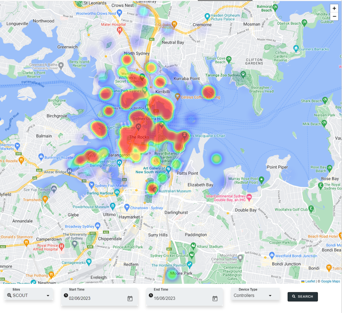
Live heatmap capture of drone activity over Sydney Harbour
D13’s unique service offering to the Australian market is underpinned by our experienced and specialised in-house workforce encompassing engineering, design and operational services. Our Australia-based team are highly experienced leaders in signals processing, artificial intelligence (AI), software and hardware engineering, mechanical design, and radio frequency.
Experience
Our capabilities and services are reinforced by our extensive heritage in military applications that have in recent years transformed to support critical infrastructure and commercial applications. Our experience in development, sustainment and innovation through acquisitions and ventures with the Australian Defence Force (ADF) have set the foundations for the capabilities and services delivered today.
Our appreciation for a range of different industries has evolved over time, acknowledging that what may work for militaries may not work for critical infrastructure clients. This has led to the formation of cooperative engagements with critical infrastructure clients to refine functional and non-functional user requirements to deliver a tailored solution. An example of this is the decision for our user interface, Atlas to primarily be offered as a cloud service offering. This enables the interface to be accessible to active / live databases of information such as ADS-B, air navigation data and other geographical resources as required. In certain circumstances D13 continually engages with prospects to ensure future design considerations are understood now, with the system remaining adaptable throughout.
A key tenant of our experience is through the application of real-world deployments across Australia. There are D13 systems deployed across Australia supporting Law Enforcement Agencies (LEAs), Critical Infrastructure, Australian Defence Force (ADF), Correctional Facilities and events. Our systems are providing early warning detection and pattern-of-life analysis to these entities in a mix of environments including high-density metro (i.e., cities – Sydney, Melbourne, Canberra, Adelaide) and low-density rural, austere environments (i.e., regional South Australia and Western Australia). These systems are deployed in both singular and networked configurations to meet the needs of the end user.
Drone detection system
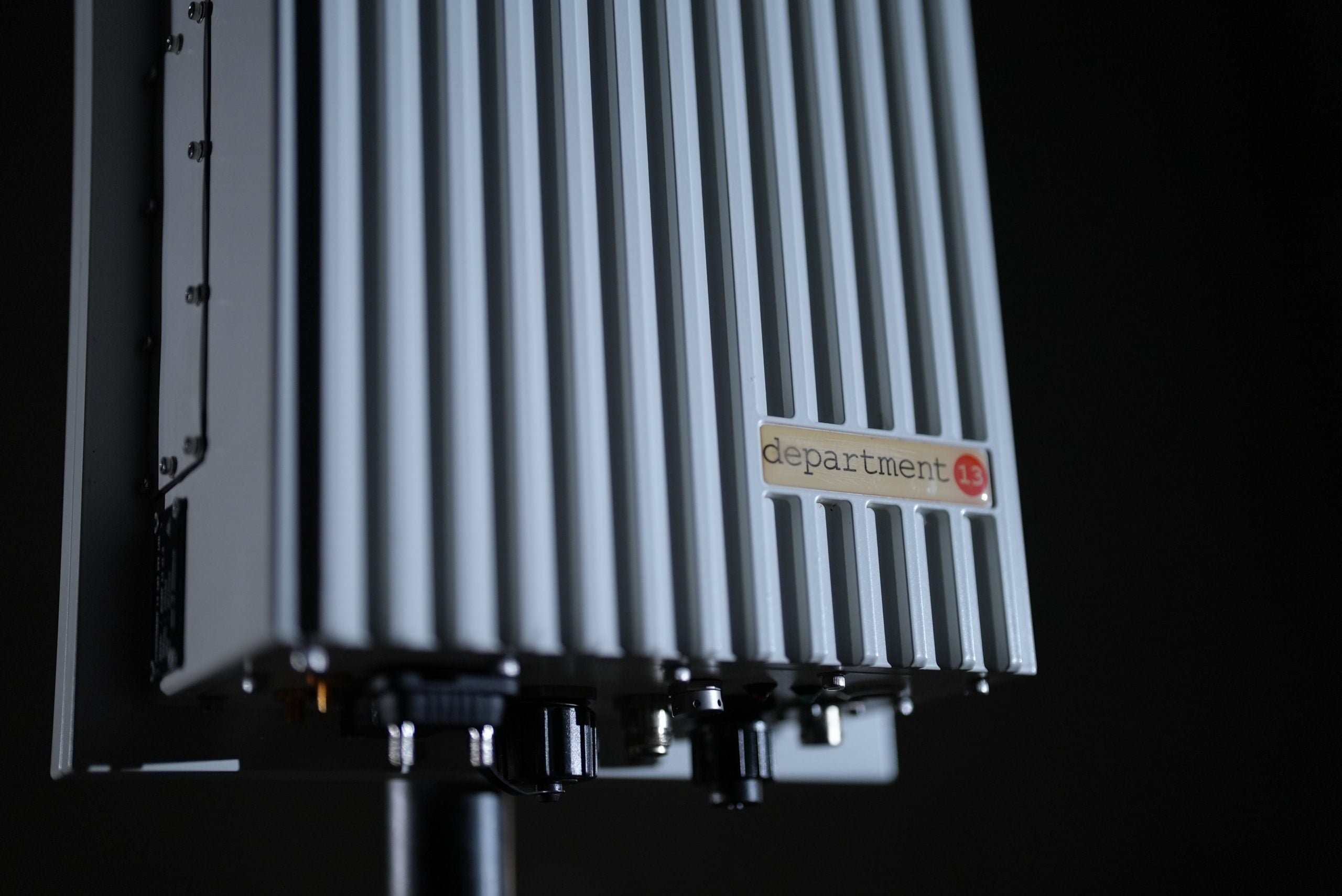
At the core of D13’s capabilities are its passive RF based sensor unit – Scout. Scout is a compact hardware unit designed and assembled by D13 engineering staff to meet the needs of the Australian domestic market. Using a singular antenna system, Scout provides 360 degrees detection coverage from its installed location, minimising the impact on installed infrastructure.
Prioritising locally sourced Australian commercial-off-the-shelf (COTS) components and internationally where required, Scout provides a true sovereign capability that is not reliant on legacy hardware units in service by some government organisations and is free from foreign influence or control. Specifically designed for the Australian environment, Scout has and continues to undergo rigorous environmental test and evaluation exposure with active clients, and through D13’s creation of a multi-sensor distributed test environment in high-density urban environment. Furthermore, Scout is RCM compliant and open API enabled (RESTful) for integration into existing systems or other C2 systems.
As a passive only RF based system, Scout listens for the unique signals UAS and GCS are transmitting within the unlicenced ISM bands that commercial manufacturers utilise. Whilst capable of operating up to 6Ghz, Scout has been tuned to detect UAS/GCS within the 2.4Ghz and 5.8Ghz, where many commercial drones operate. Within these frequency ranges, with a validated operational planning range of 5km in low-density urban environments and 2.5km in high-density urban environments, Scout can detect a range of manufacturers including but not limited to DJI, Autel, Skydio, Parrot, SwellPro and various Wi-Fi based UAS (a comprehensive list of UAS/GCS available in the system can be provided upon request).
Upon detection of the UAS/GCS, Scout extracts further information from within the communications protocol signal providing it to the operator:
Telemetry of UAS and GCS (GPS accurate location, height, bearing), if available
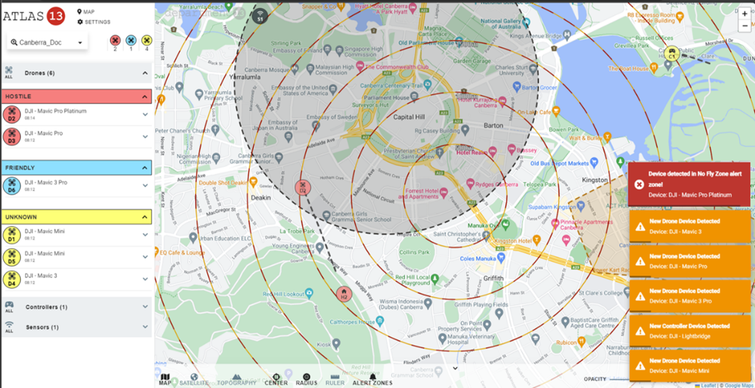
Cloud-based user interface
The above detection, identification and tracking information is then communicated to D13’s cloud-based graphical user interface – Atlas. Using the scalability, flexibility, redundancy and security of cloud-based platform, Atlas collates all detection data as per the user’s permissions and profile which is accessible from a web browser. Upon receiving the data from Scout sensor/s, Atlas provides the following services to the operator:
Visual and audible alerts/alarm of new UAS/GCS detection
Visualisation of all detected UAS/GCS information
Alert zones
Email notification of alerts
User defined categorisation of threat (Unknown, Hostile, Unfriendly)
Live visual tracking on graphical map of UAS and/or GCS
User defined selection of illustrative or satellite map
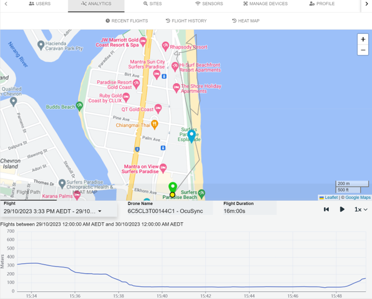
In addition to the above, Atlas has further in-built capabilities for users to access including history/analytics of previous UAS/GCS events, user and sensor management.
Atlas enables the searching or viewing of user defined criteria of past UAS and GCS events. Users can quick search last 4hr, 8hr, 12hr, 24hrs or for more expansive searches a specific date range can be selected. The search results provide a user with a list of past events or the grouping of multiple events of the same UAS/GCS for ease of comprehension. Once an event is selected the user is provided the available data including flight path and height (if available).
Users can replay events whilst also selecting the ability to get a hotpot summary of the flight/s. All delivered search results and subsequent data are completely exportable in .CSV, PDF and KML file formats for use in other applications or functions. Furthermore, heatmapping is available within the platform to provide wholistic pattern of life intelligence sharing same searchable criteria functions.
D13 has adopted a continuous collaborative design approach with Australian Government, Law Enforcement, Critical Infrastructure and commercial operators to ensure the features and usability of the system remains relevant, adaptive and tailored. The collaborative engagement with these entities ensures that user requirements are directly inputted into future versions and industry specific requirements (e.g., air navigation mapping overlay) can be rapidly integrated as needed.
Hindered by limited awareness and lacking tools to combat the risks, a major Australian mine operator turned to Department 13 International (D13) and their cutting-edge solution, Scout13, to tackle the escalating drone threat and safeguard their critical infrastructure.
Whether you are a holder of an exploration license or a fully operating mine, you need to ensure your project is kept safe and secure from risks which can develop from drones flying close to projects or exploration work.