
Salty groundwater has been detected in many boreholes drilled in the Western Province of Zambia, but the exact spatial extent and nature of the salty groundwater was not fully understood, so an investigation was needed. To get a map showing the spatial distribution of salty groundwater 1D electromagnetic (TEM) soundings were made with an ABEM WalkTEM system.
"The user interface when conducting measurements and the fact that the transmitter and receiver are all located in one case are what gives the ABEM WalkTEM its most benefits. It made the field work very convenient", said Mkhuzo Chongo, a PhD student of environmental engineering / geophysics at University of Zambia.
"The spatial distribution of electrical resistivity in the study area has been mapped and we are still interpreting the results to come up with a map showing the spatial distribution of salty groundwater in part of the study area"
The project was part of a Danish International Development Agency (DANIDA) supported programme. Through the Danish Embassy in Lusaka the Danish Government initiated a capacity building project for the water sector in Zambia through the University of Zambia (UNZA), with technical assistance from GEUS and DTU. GEUS was mandated to do everything possible to ensure capacity was built, including procurement of equipment and other training materials.
ABEM solution used in the project:
ABEM WalkTEM 2 channels with one RC5 receiver antenna, one RC200 receiver antenna, one 40m x 40m transmitter loop, one 100m x 100m transmitter loop and one 200m x 200m transmitter loop. The project members also had on-site training by ABEM.
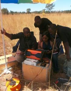
Image: The WalkTEM system was used to investigate a groundwater resource the University of Zambia. Photo: courtesy of ABEM.