
 Potash Project, Afar")
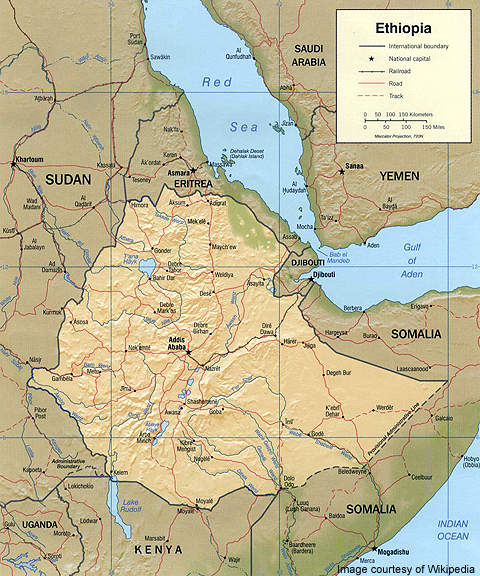
Danakhil potash project is located in Ethiopia’s north-eastern Danakhil depression, a desert area in the region of Afar. The project initially included three potash concessions covering an area of approximately 150 square kilometres.
Recommended Buyers Guides
A fourth concession covering 11 square kilometres was acquired from Haro Exploration in 2010. It includes two deposits: the Mushley deposit and the smaller Crescent deposit.
The project is owned by Allana Potash, which began phase one drilling on 5 April 2010. The drilling programme continued through 2010 and 2011, exploring potential potassium mineralisation in the concessions. China Investment Corporation is considering investing in the project.
Tesla-IMC International conducted a 2D seismic survey on the project from October to December 2010. The feasibility study of the project was awarded to ERCOSPLAN in September 2011. The preliminary economic assessment of the project was completed in November 2011.
Reserves and geology of the potash project
The deposit contains an estimated 588.2 million tons of inferred potash mineral resources according to the revised estimates reported in June 2012.
The composite grade of the resources has been estimated at 18.6% KCI. The total measured and indicated resources are estimated at 1.29 billion tons at 19.3% KCI. The mine lies within the Danakhil depression, a northern extension of the Afar depression.
The north-west / south-east striking depression extends across 200km from Lake Badda in the north-west to Lake Acori in the south-east. The geological structure of the depression is ten kilometres wide in the north and broadens up to 70km in the south. It is characterised by elevations as low as 50m to 128m below sea level.
Towards the north-west, the Danakhil depression is surrounded by the Danakil Alps. The Alps, with 1,000m elevations, contain a 40-70km-wide horst structure that divides the depression from the Red Sea. The south-western border of the depression has elevations of 2,100m.
A 1,000m series of evaporite is formed close to Red Sea due to the high rates of subsidence. The shoulders of the Danakil Alps and Ethiopian highlands include gneisses and phyllites belonging to the Precambrian age. It also comprises Jurassic-age sediments and granites, and intruded basalts belonging to the Palaeozoic and Neogene age.
The border zone between the highland and depression consists of tertiary to quaternary alluvial fan sediments. Largely unconsolidated, the sediments interfinger and lie above the Pleistocene and Holocene sediments of the depression.
Basement rocks of the deposit consist of gneisses, phyllitic schists, limestones, sandstones and conglomerates of the Palaeozoic and the Precambrian age. Found mostly in the eastern, western and border areas of the zone, the basement rocks do not outcrop. They are overlain by a series of Mesozoic rocks, including Adigrat Sandstones, antalo limestones, marls and upper sandstones. It is overlain by a series of tertiary and quaternary rocks.
The structure of the potash members found within the deposit dip gently by less than 50 in the north-east direction. The deposit is segmented into blocks depending on the thickness, grade and depth of the surface of the horizons.
Mineralisation at the Danakhil potash project
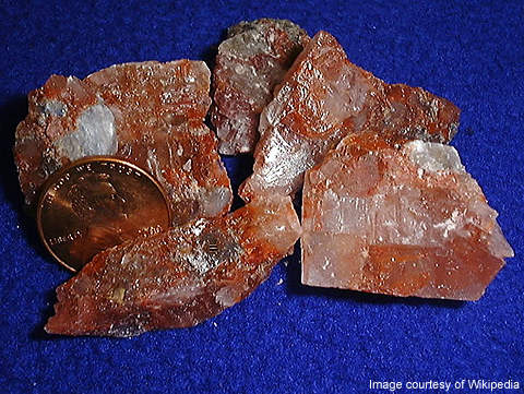
The deposit hosts four main potash bearing minerals including sylvite, carnallite, polyhalite and kainite. Three layers that comprise different constitution of potash minerals dominate the deposit.
The sylvinite layer ranges up to 11m in thickness and comprises large amounts of sylvite along with trace amounts of carnallite, anhydrite, clay and dolomite.
The kalnitite member that averages nine metres in thickness is dominated by kainite with lesser amounts of kieserite, carnallite and insoluble material.
Mining and processing at Ethiopia’s deposits
Related project
Sintoukola Potash Project, Kouilou, Congo
The Sintoukola potash project is located in Kouilou Province of the Republic of Congo in West Africa.
The deposit will be mined using either solution or open pit mining methods. The feasibility of these options is being investigated. Hydrogeological investigations will reveal the potential of open pit mining for the deposit. Mining will be carried out either through solution mining or conventional mining, if the deposit’s depth is increased further. A combination of solution and conventional mining techniques can also be adopted.
The alternatives currently under consideration for processing the minerals include MOP production from solution and conventional mining of the sylvinite member and production of SOP and K-Mg sulphate from conventional and solution mining of the kainitite member.
Under the solution mining method of the sylvinite member, MOP is produced from the brine received by solution mining of a sylvinite deposit. MOP production from conventional mining of a sylvinite deposit includes mechanical separation and hot leaching of the ore to form a KCI liquor that is further crystallised.
Under conventional mining of the kainitite member, SOP and K-Mg sulphite are produced by separating kainite and kieserite from halite. K-Mg sulphates are converted into K sulphates through reaction with additional KCI. SOP and K-Mg sulphite production through solution mining of the Kainitite member is not a proven process. A pilot operation is conducted before the composition of the final brine / slurry is determined.
Drilling at Allana Potash’s project
The phase one drilling programme of the deposit was initially planned to include seven holes extending between 2,500m and 3,000m. The number of holes have however been increased with more potential potash mineralisation being identified.
Designed to confirm the accuracy of the historical drilling results besides increasing the resource limit, the drilling programme is being conducted at the potash horizons closer to the current resources. The potash horizons hosted in the centre of the evaporite basin are also being tested.